Field operations are facing increasing requirements in terms of reliability, responsiveness, and data quality. For network operators and public works companies, it has become essential to rely on tools that reduce rework, secure field operations, and streamline exchanges between the jobsite and the office.
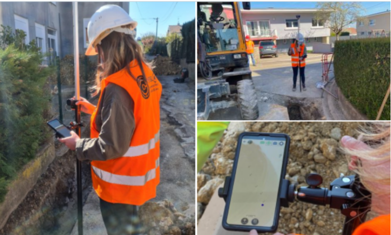
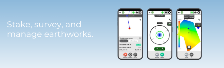
EasyField addresses these challenges by turning a smartphone or tablet into a practical surveying tool tailored to field use. The application covers staking, topographic surveying, and earthworks control within a single mobile environment.
EasyField, a mobile surveying application focused on simplicity and accuracy
Designed for everyday geospatial operations, EasyField combines:
centimeter-level GNSS accuracy,
an intuitive interface,
a smooth workflow,
compatibility with CAD formats (DXF, DWG) as well as point list formats (CSV, TXT, XLSX, ODS).
From an iOS or Android smartphone or tablet, plans can be viewed directly in the field, operations are guided step by step, and topographic data is captured and verified throughout the intervention. The goal is to reduce time spent on site while ensuring the reliability of the data produced.
Staking: fast and plan-compliant field execution
Site staking plays a key role in the success of a project: it ensures the accurate transfer of execution plans to the field by guaranteeing precise positioning of structures, and helps prevent construction errors or delays caused by rework. As a critical phase, it requires reliable tools that can be quickly deployed on site.
Turning a digital plan into an operational guide
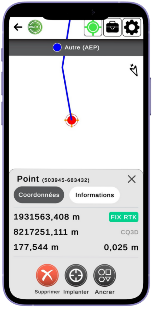
EasyField allows you to import your plans in DXF and DWG formats and view your elements (points, lines, areas) directly on mobile. The application then provides real-time guidance, including:
distance indication,
direction to follow,
confirmation upon arrival.
Benefits for field teams
With EasyField, staking becomes an accessible operation, even without advanced surveying expertise:
Faster staking
Greater autonomy for field teams
Access to always up-to-date georeferenced data
Reduced travel and rework
Less reliance on subcontractors
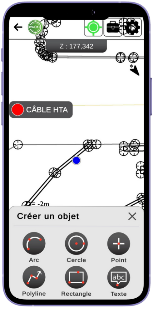
Topographic survey: capturing field reality in just seconds
Topographic surveys are essential for updating underground networks, documenting project progress, or preparing future works.
Simplified topographic surveying
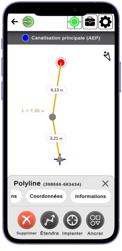
EasyField allows you to capture:
points,
polylines,
circles and arcs,
surfaces.
Each measurement is recorded with a level of accuracy suited to your operational requirements and can be exported in DXF or DWG for immediate integration.
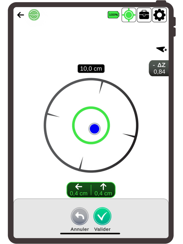
Quality validation at the point of capture
Survey quality is checked at the moment of capture, allowing measurements to be validated immediately and avoiding any later rework. The application continuously displays:
GNSS information,
expected accuracy.
Result: a survey validated on the first attempt, with no rework required.
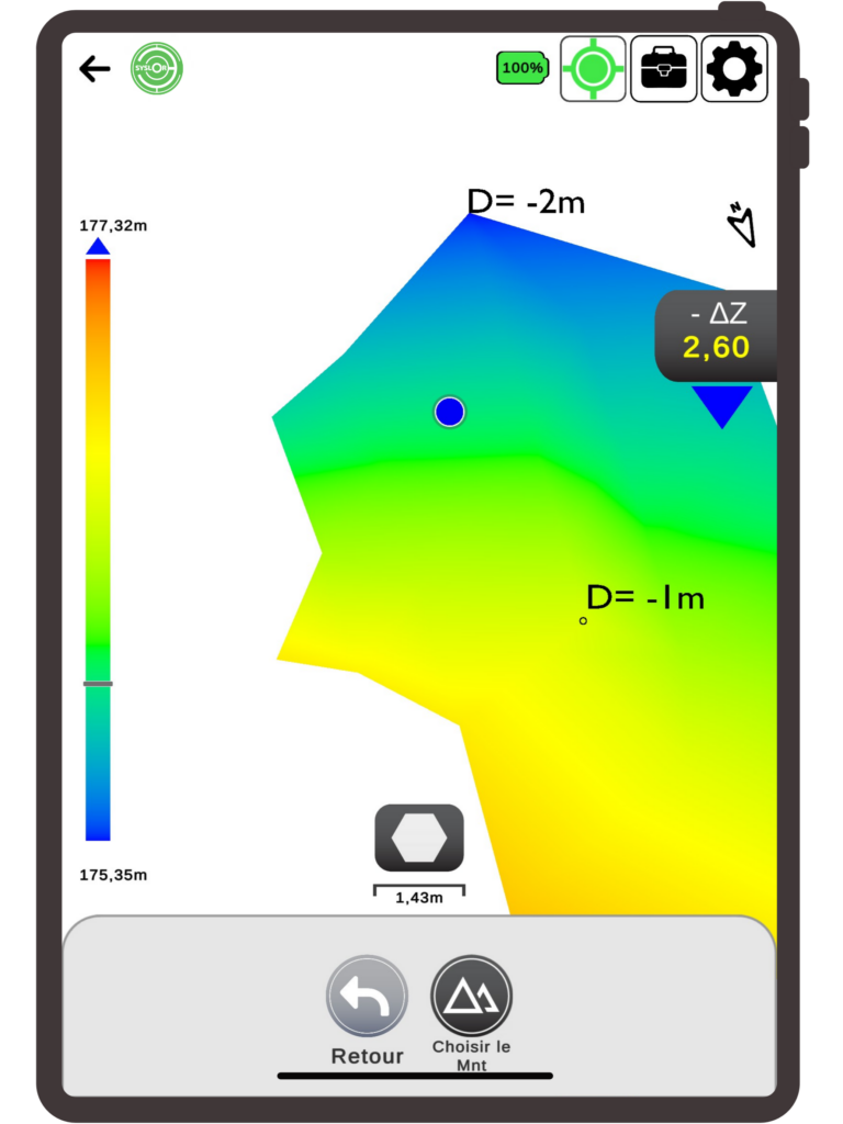
Earthworks: immediate control and optimization of earth movements
Earthworks often represent a significant portion of a project’s budget. Poor cut-and-fill estimation can lead to major cost overruns.
Project surface analysis
EasyField allows you to import your DTMs (Digital Terrain Models) to compare:
existing terrain,
proposed terrain.
Identify areas to be corrected at a glance
The application automatically displays:
cut areas,
fill areas,
surface areas,
elevation differences.
This allows adjustment decisions to be made immediately, based on reliable data.
Who is EasyField for?
EasyField is designed to meet the needs of different stakeholders facing the same challenges: saving time, improving the reliability of field operations, reducing errors, and streamlining data flow between the field and the office.
Here’s how the application adapts to each user profile.
Surveyors: remote supervision, validation, and reduced travel
For surveyors, one of the main challenges is the frequent back-and-forth between the field and the office, as well as data transfer between teams.
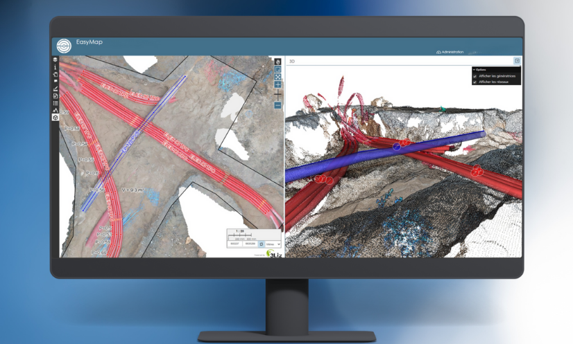
The value of EasyField truly comes into play when used with the Syslor platform, which centralizes plans, synchronizes surveys, and ensures data consistency between the design office and the jobsite. This office ↔ field workflow guarantees controlled production and greater operator autonomy.
With the application, surveyors can:
prepare staking plans in the office and instantly send them to field teams,
retrieve surveys without traveling to the site,
review data immediately after it is generated,
focus their time on truly critical operations.
EasyField becomes an operational support tool, allowing surveyors to work more efficiently while maintaining full technical control over their data.
Underground network operators and asset managers: ensuring reliable cartographic updates
For underground network operators and asset managers (water, electricity, telecom, gas, wastewater), keeping cartographic data up to date is essential to improve:
safety,
network maintenance,
asset knowledge,
regulatory compliance.
Teams have access to georeferenced surveys that can be immediately integrated into GIS or CAD systems.
On site, you can:
accurately survey installed networks,
document each asset in real time,
reduce cartographic update delays,
limit the risks of mislocation or uncertainty.
Information becomes reliable, standardized, and immediately integrable into the network asset database.
Field operators: a guided and intuitive interface
Not all field operators are trained in surveying. EasyField is designed with them in mind, with an interface that makes every action easy to understand.
The application simplifies:
onboarding in just a few minutes,
viewing plans directly on mobile,
visual guidance for staking and surveying,
real-time validation of captured points,
automated data export.
No surveying expertise is required: the tool builds confidence for field teams and ensures reliable results from the first attempt.
Why choose EasyField ?
EasyField fits into a structured approach to field operations by combining data reliability, ease of use, and interoperability with existing tools.
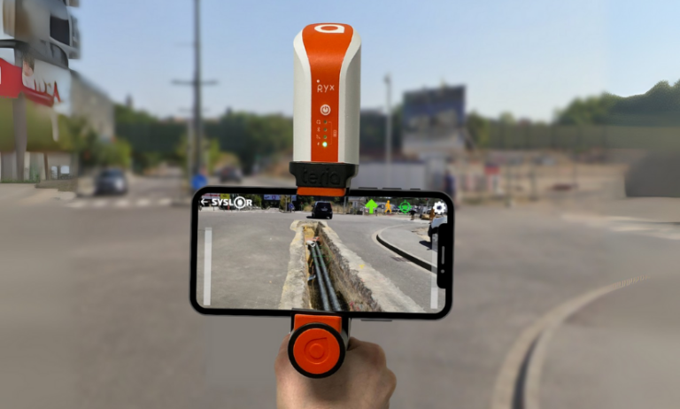
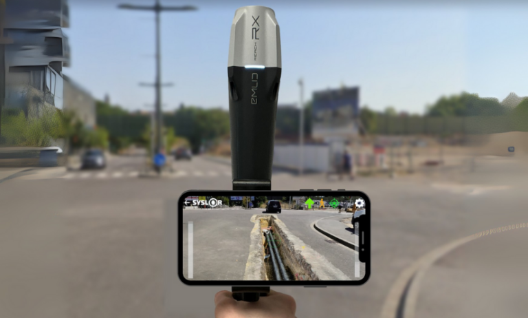
Certified GNSS accuracy tailored for public works
EasyField works with our Proteus GNSS receiver as well as Emlid Reach RS2 and Teria Pyx GNSS receivers, ensuring centimeter-level accuracy essential for:
staking,
topographic surveying,
earthworks control,
network updates.
Measurement quality is displayed directly in the application, allowing data to be validated at the moment of capture, with no risk of error.
Reliable data from the start means less rework, less uncertainty, and lower costs.
Unmatched ease of use
EasyField is designed to be used by any team member, even without surveying experience.
The application is built around:
clear visual guidance,
consistent workflows.
This simplicity significantly reduces:
handling errors,
training requirements,
dependence on technical experts.
Your smartphone becomes a professional tool that is immediately operational.
Time savings and cost reduction at every stage
EasyField optimizes the entire operational cycle:
fewer unnecessary trips,
less subcontracting,
less rework,
less time spent reprocessing data,
better collaboration between the field and the office.
Compatibility with your software ecosystem
EasyField integrates seamlessly into your production workflow:
import for processing: DXF, DWG, DGN,
survey export: DXF, CSV,
compatibility with CAD, GIS, and industry-specific software.
Field data becomes immediately usable by:
surveyors,
CAD technicians,
site managers,
GIS operators.
No more complex conversions or information loss.
Unlimited use, with no tokens and no hidden costs
Unlike some market solutions based on token or credit systems, EasyField operates on a subscription model. Once subscribed, you benefit from fully unlimited use:
unlimited surveying,
unlimited staking,
unlimited earthworks,
unlimited number of jobsites.
No surprises. No additional costs based on usage volume.
You stay in control of your budget while encouraging internal adoption across all your teams.
A simple, transparent model suited to companies of all sizes.
A concrete answer to your challenges
By bringing staking, topographic surveying, and earthworks into a single mobile application, EasyField simplifies the organization of on-site operations while ensuring the quality of the data produced.
The tool integrates naturally into existing production workflows and allows teams—from the field to the office—to work with reliable, consistent, and immediately usable information.
Would you like to try EasyField?
Take advantage of a personalized demo to explore its features and how it integrates into your workflows.
Schedule your demo today.