Reliable data,
delivered faster,
without compromise.
Your role is to provide your clients with accurate, actionable data within ever shorter timeframes. Syslor gives you the tools to achieve this—without multiplying site visits or manual re-entry.

With Syslor, you transform client relationships into a shared workflow between office and field—enabling more sustainable partnerships and unmatched responsiveness.
What your teams
experience every day
Every engineering firm has its own priorities. Discover how Syslor can support you with practical solutions tailored to your workflows.
Save time on every project
Coordination between field and office often remains time-consuming: incomplete exchanges, processing delays, multiple site visits by the surveyor… all factors that slow down projects.
Make the most of collected data
Managing large volumes of data while meeting Class A regulatory requirements means balancing accuracy, reliability, and efficiency at every stage.
Build client loyalty
Your clients’ trust relies on the quality of your deliverables and the transparency of the information you share—expectations that are becoming increasingly demanding.
Ensure proper execution of works
Ensuring compliance between design plans and as-built works is essential to prevent discrepancies, secure networks, and produce reliable as-built documentation.
Tools designed to meet
your field needs
Mobile apps for your field operators, a web portal for your surveyors—an end-to-end workflow.
From video capture to compliant as-built documentation in 30 minutes.
Film your open trench with your smartphone. EasyScan automatically generates a georeferenced 3D point cloud and a Class A as-built plan—without heavy equipment or a surveyor on site.
The all-in-one vectorization solution for your as-built documentation.
EasyMap is a vectorization module that transforms your photogrammetric data into Class A as-built plans, leveraging tailored attribute libraries, orthophoto stitching for long linear assets or large areas, and a dual 2.5D / 3D view for reliable and intuitive elevation control.
Visualize your underground networks in augmented reality to improve accuracy and safety.
EasyView turns your smartphone or tablet into a 3D visualization tool for underground networks directly on site. Combining augmented reality with GNSS accuracy, you can mark, stake, and maintain markings in no time, while reducing damage and delays.
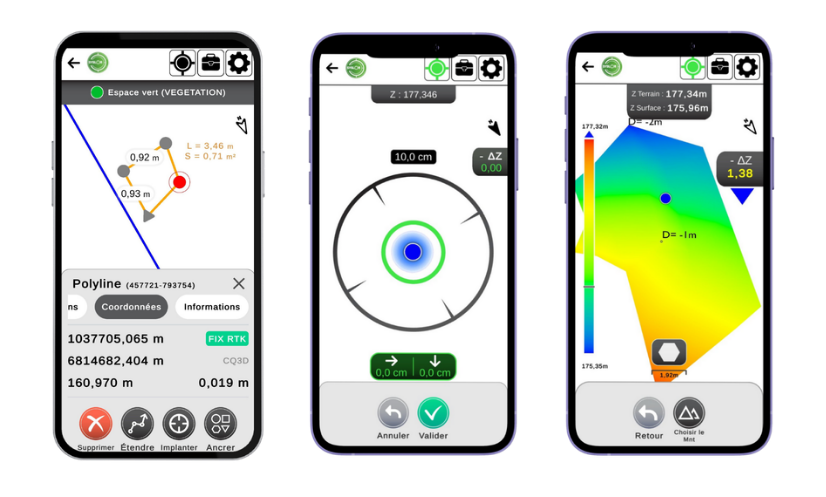
Set out, survey, and carry out earthworks with precision, directly from your smartphone.
EasyField is your digital field notebook for site setting out, earthworks monitoring, and fast, reliable, and intuitive surveys, with unlimited use and compatibility across smartphones and tablets.
Responsible tools,
built to last
At Syslor, we provide tools tailored to your use cases while meeting your operational and environmental requirements.
Digital sovereignty
Our equipment is designed and manufactured in France, and all data is hosted within the country. Technological sovereignty serving your operational security.
Efficiency and performance
Reducing damages, avoiding unnecessary site visits, and improving network control—concrete actions to limit environmental impact and promote sustainable management.
Designed for your real-world needs
Our mission is to make network data accessible, actionable, and truly useful on a daily basis—both in the field and in the office.


Ready to simplify your field-to-office workflow?
A Syslor expert will present solutions tailored to your context, deliverables, and constraints. No commitment required.