Secure networks,
reliable data.
Ensuring infrastructure safety, tracking interventions, and guaranteeing accurate network positioning is an ongoing challenge. Syslor provides the tools to achieve it — with precision, both in the field and in the office.
With Syslor, every intervention is tracked, potential damages are anticipated, and project progress is monitored with precision — helping you improve efficiency, reduce costs, and enhance the safety of your networks.
What your teams experience
every day
Infrastructure safety, intervention tracking, field-to-office collaboration, and managing your data within your GIS… Discover how Syslor provides practical solutions to each of these challenges, with tools that are easy to deploy and tailored to your operational needs.
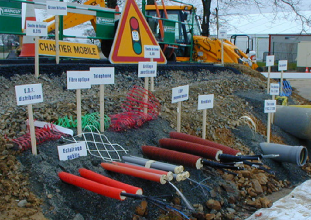
Avoid damage to infrastructure
Interventions near sensitive networks expose your teams to risks and can lead to errors caused by discrepancies between plans and on-site reality. Marking and staking can sometimes lack precision, increasing the risk of incidents.
Export your deliverables in your GIS formats
The diversity of GIS formats can make data exploitation more complex and hinder collaboration with your contractors, especially in the face of technological and regulatory changes (Class A, photogrammetry, etc.).
Monitor work execution
Your responsibilities as a network operator require you to ensure the quality of network installation and to coordinate stakeholders with rigor and transparency.
Plan projects at a territorial scale
Designing, prioritizing, and securing infrastructure projects requires reliable, up-to-date, and easily usable network data. Without this foundation, it becomes difficult to maintain a clear and shared view of your territory.
Build an asset database
Effective network asset management relies on rigorous and accessible data centralization. Without it, decision-making remains fragile and collaboration between teams becomes inefficient.
Integrate decarbonization into network management
Reducing emissions on construction sites requires more efficient practices and better use of field data. Every trip, survey, or intervention adds to the project’s carbon footprint.
Tools designed to meet
your field needs
Mobile applications for your operators, a web portal to manage your data — an end-to-end workflow.
From video capture to compliant as-built in 30 minutes.
Film your open trench with your smartphone. EasyScan automatically generates a georeferenced 3D point cloud and a Class A as-built plan — without heavy equipment or a surveyor on site.
The all-in-one vectorization solution for your as-built deliverables.
EasyMap is a vectorization module that transforms your photogrammetric data into Class A as-built plans, leveraging tailored attribute libraries, orthophoto concatenation for long linear projects or large areas, and a dual 2.5D / 3D view for reliable and intuitive elevation control.
Visualize your underground networks in augmented reality to improve precision and safety.
EasyView turns your smartphone or tablet into a 3D visualization tool for underground networks, directly on site. Thanks to augmented reality and GNSS precision, you can mark, stake, and maintain markings in no time, while reducing damages and delays.
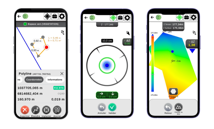
Stake out, survey, and manage earthworks with precision, directly from your smartphone.
EasyField is your digital field notebook for site layout, earthworks monitoring, and fast, reliable, and intuitive surveying, with unlimited use and full compatibility with smartphones and tablets.
Responsible tools,
designed to last
At Syslor, we are committed to supporting you in updating your GIS by ensuring accurate Class A data and enabling you to meet all current regulatory requirements.
Digital sovereignty
Our equipment is designed and manufactured in France, and all data is hosted within the national territory. Technological sovereignty serving your operational security.
Efficiency and sustainability
Reducing damage, avoiding unnecessary travel, and better controlling network infrastructure are all concrete actions that help limit environmental impact and support sustainable territorial management.
Designed for your operational realities
Our mission is to make network data accessible, actionable, and useful every day — enabling you to make informed decisions and act efficiently, both in the field and in the office.


Ready to better secure your networks and operations?
A Syslor expert will present solutions tailored to your context, your requirements, and your constraints. No commitment.