Safer job sites,
more autonomous teams.
As a public works contractor, you need to protect your teams, prevent damage to existing networks, and keep full control over timelines and costs. Syslor gives you the tools to achieve this — simply, directly in the field.

With Syslor, your field operators can directly access network data on-site, track their work, and share information in real time — helping you save time, reduce travel, and streamline site operations with centimeter-level accuracy.
What your teams face
every day
Keeping your teams safe, optimizing site organization, reducing travel, and better documenting your work… Discover how Syslor supports you with practical, easy-to-use solutions designed for the field.
Secure your operations
On job sites, the top priority is to prevent damage and ensure people’s safety when working near sensitive underground networks.
Document damage incidents
When damage occurs, the challenge is to establish an objective record and rely on solid, factual data to clarify responsibilities.
Save time throughout the job site
Marking and staking is time-consuming and prone to errors. Communication between field and office slows down operations and delays trench closure.
Ensure proper execution of works
Ensuring that work complies with Class A requirements and matches planned layouts is essential to avoid discrepancies, secure networks, and ensure reliable as-built records.
Reduce the carbon footprint of your operations
In the field, every avoided trip and every anticipated rework means time saved, lower costs, and fewer emissions. Environmental performance also comes down to operational efficiency.
Facing one of these challenges?
A Syslor expert is here to support you.
Tools designed to meet
your field needs
Mobile apps for your field operators, a web portal for your surveyors—an end-to-end workflow.
From video capture to compliant as-built documentation in 30 minutes.
Film your open trench with your smartphone. EasyScan automatically generates a georeferenced 3D point cloud and a Class A as-built plan—without heavy equipment or a surveyor on site.
The all-in-one vectorization solution for your as-built documentation.
EasyMap is a vectorization module that transforms your photogrammetric data into Class A as-built plans, leveraging tailored attribute libraries, orthophoto stitching for long linear assets or large areas, and a dual 2.5D / 3D view for reliable and intuitive elevation control.
Visualize your underground networks in augmented reality to improve accuracy and safety.
EasyView turns your smartphone or tablet into a 3D visualization tool for underground networks directly on site. Combining augmented reality with GNSS accuracy, you can mark, stake, and maintain markings in no time, while reducing damage and delays.
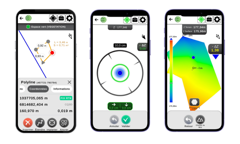
Set out, survey, and carry out earthworks with precision, directly from your smartphone.
EasyField is your digital field notebook for site setting out, earthworks monitoring, and fast, reliable, and intuitive surveys, with unlimited use and compatibility across smartphones and tablets.
Responsible tools,
built to last
At Syslor, we support public works contractors in their day-to-day operations—between office and field—with simple, precise tools designed for long-term use.
Digital sovereignty
Our equipment is designed and manufactured in France, and all data is hosted within the country. Technological sovereignty that supports your operational security.
Efficiency and sustainability
Reducing network damage, avoiding unnecessary travel, and improving network control—these are concrete actions that help limit environmental impact and support sustainable territory management.
Designed for your operational realities
Our mission is to make network data accessible, actionable, and truly useful on a daily basis—so you can make informed decisions and act efficiently, both in the field and in the office.


Ready to secure your job sites and your teams?
A Syslor expert will walk you through solutions tailored to your context, regulatory requirements, and operational constraints. No obligation.