Optimising network management using augmented reality: a case study from a petrochemical site

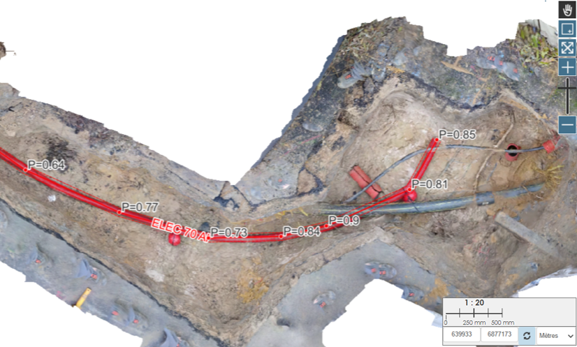
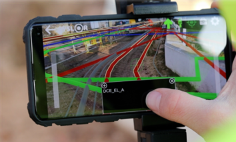
Securing industrial sites with modern network mapping At an industrial petrochemical site in eastern France, the presence of sensitive networks is a major safety issue. The existing plans were obsolete and difficult to use in the field, making it difficult to prepare and secure operations. Faced with these challenges, the site’s management approached Syslor to provide a solution for digitising network data and securing marking & staking. Safety, reliability and efficiency in the field On this industrial site with a high safety profile, the customer had three major priorities: Reduce the risk of damage to underground infrastructures Ensure reliable mapping of sensitive networks on a site with high safety requirements Quickly visualise networks in the field without the need for complex tools Solution deployed: EasyView for industrial safety Syslor implemented its EasyView solution, integrated with the specific constraints of the site: Proteus GNSS receiver for reliable centimetre-level location EasyView mobile application for augmented reality viewing of underground networks Conversion of plans and automatic tiling of existing networks to make them usable on mobile User support and training Key features used Instant visualisation of all networks using the customised conversion key Display of critical attributes defined by the customer: installation date, class, depth, type of network, diameter On-board access to complete mapping: all buried networks on site accessible to the operator Results achieved Immediate availability: work could begin immediately Centimetre-scale visualisation of networks directly in the field Significant reduction in marking time by a factor of 4 Access to reliable, up-to-date data in real time, anywhere. Increased reactivity 24 hours a day. An essential tool for operations on industrial sites Thanks to EasyView, the petrochemical industrial site now has an intuitive, secure mobile tool for visualising its underground networks. Field teams can intervene faster, with fewer risks and always up-to-date information, directly with their smartphone. Are you working on an industrial or SEVESO classified site? Find out how EasyView can transform the way you manage underground networks. Contact us or request a demonstration.

Optimising network management using augmented reality: a case study from a petrochemical site Read Post »

Proteus: A Labeled Innovation for Smart Utility Network Management

The Proteus GNSS receiver labeled “Solar Impulse Efficient Solution” In a world where environmental challenges are becoming increasingly urgent, concrete and cost-effective solutions are essential. In this context, Syslor was awarded the “Solar Impulse Efficient Solution” label in 2021 for its GNSS receiver named Proteus, marking a key milestone in its commitment to sustainable innovation. In 2024, this recognition was renewed, highlighting the continued relevance of the Proteus solution in addressing the challenges of ecological transition. What is the “Solar Impulse Efficient Solution” label? Created by the Solar Impulse Foundation, founded by Swiss explorer Bertrand Piccard, this label recognizes solutions that combine environmental performance with economic viability. Its goal is to promote 1,000 clean technologies capable of accelerating the ecological transition without compromising profitability. To earn this label, each solution is assessed by independent experts based on three criteria: feasibility, environmental impact, and profitability. Proteus: A Labeled Innovation for Smart Utility Network Management The Proteus technology, developed by Syslor, has successfully met these strict requirements.It is a real-time geo-referencing solution for underground utility networks, which enables: Reduced costs related to interventions and network damage Lower environmental impact of construction works Improved accuracy and traceability of operations Smoother communication between construction and public works stakeholders Thanks to this innovation, local authorities, public works companies, and utility managers have a practical tool to reduce their carbon footprint while optimizing their operations. View the official Proteus listing on Solar Impulse A Recognition That Reinforces Syslor’s Mission Being labeled by the Solar Impulse Foundation means joining an international community of providers of sustainable and efficient solutions. For Syslor, it represents a strengthened commitment to meaningful and responsible innovation. The renewal of the label in 2024 confirms the robustness and added value of Proteus, and reinforces our ambition to provide stakeholders with practical tools to address the challenges of the energy transition — with a focus on local impact, reliability, and performance. In conclusion By joining this initiative, Syslor is committed to putting technology at the service of a more sustainable future — without compromising on efficiency.

Proteus: A Labeled Innovation for Smart Utility Network Management Read Post »

How to process and exploit point clouds effectively?

Photogrammetry has become an essential technique for documenting and analyzing construction sites, particularly in the context of as-built surveys of underground networks.It enables the production of georeferenced deliverables in various forms, such as point clouds, orthophotos, digital terrain models (DTMs), or even 3D meshes. Photogrammetric deliverables can be difficult to leverage due to the complexity of the data and the analyses required.Fortunately, some software tools—such as EASYMAP®—accessible through our web portal, greatly simplify this process, making these deliverables far more accessible to non-expert users. Let’s explore the practical applications of data collected using as-built tools like EasyScan®. Solutions for leveraging data collected through as-built surveys Vector mapping of utility networks Combining orthophotography with a digital terrain model (DTM) enables vertical projection, making it easy, fast, and accurate to vectorize the upper generatrices in 3D. This vectorization can be exported in various formats, allowing it to be used and integrated into Geographic Information Systems (GIS) or Computer-Aided Design (CAD) software, ensuring smooth interoperability between all project stakeholders. Example of upper generatrix tracing of an electrical network using Sysmap Handling longitudinal and cross-sectional profiles This vectorization comes with the ability to generate longitudinal and cross-sectional profiles, enabling continuous control of the tracing process. This ensures tracing reliability that meets the accuracy requirements of Class A. Profiles based on an electrical duct Longitudinal profile Cross-sectional profile Profiles produced with Sysmap Area measurement and cut/fill volume computation The drawing interface allows users to measure the surface areas of intervention zones, making it possible to directly assess excavated areas and optimize land use.This surface also serves as the basis for precise volumetric measurements.The Sysmap solution helps optimize earthwork costs by providing accurate resource estimates and ensuring project compliance. Area and volume computations using Sysmap Depth measurement of utility networks During network as-built surveys, photogrammetric deliverables make it possible to determine the depth of vectorized vertices from a reference surface — a crucial element for: Ensuring compliance with safety and utility location standards; Improving the quality of as-built plans by providing accurate data on pipeline burial depths. Detection of unusual depth values using Sysmap Photogrammetric deliverables go far beyond simple visualization: they enable the extraction of numerous precise measurements—vectorization, surface area, volume, depth—making them true decision-support tools for site managers and agency directors.They enhance as-built survey accuracy, optimize costs, and contribute to better management of underground infrastructure. With Sysmap—our tracing module designed to leverage photogrammetric deliverables—network tracing is performed with precision.This process ensures reliable, usable data that is essential for future projects: building asset records, reducing damage to infrastructure, saving time, and optimizing upcoming interventions. By combining high-quality surveys with dedicated tools like Sysmap, photogrammetric deliverables become true management assets—enabling more efficient and better-anticipated construction projects.

How to process and exploit point clouds effectively? Read Post »

Récepteur GNSS Reach Rx Reach RS3 Emlid

SYSLOR Solutions Now Compatible with New GNSS Receivers: Focus on Emlid’s Reach RX / RS3

The Reach RX/RS3, like many other GNSS receivers, uses the NMEA format, a universal standard for transmitting positioning data. By leveraging this protocol, we ensure that our applications are compatible with a wide range of GNSS receivers available on the market. This standardized approach offers several advantages: Simplified integration with various GNSS equipment Proven reliability in data transmission Greater flexibility in choosing your hardware With this in mind, we have expanded the compatibility of our applications to include Emlid Reach RX and Reach RS3 GNSS receivers, carefully integrating their technical features (offsets, inertial measurement unit, etc.). A More Open SYSLOR Ecosystem, Designed for Real-World Field Operations Practically speaking, you can now connect your Reach RX/RS3 directly to: EasyField, for intuitive staking and topographic surveying, EasyView, to visualize your networks, plans, and 3D models in augmented reality, EasyScan, to capture your trenches from a video and generate a certified as-built plan (Class A certification). All on Android, with no complex setup: direct Bluetooth connection, automatic GNSS stream recognition, and continuous RTK service support. Choosing SYSLOR Means Choosing a Field-Centric Solution Intuitive interface, even without surveying experience Web portal for project data tracking and management Real-time synchronization between the field and the office A responsive hotline to support you daily Regular technical updates and new features Our promise: to support you from the field to the office with a coherent, scalable system tailored to your real-world needs. Already Working with a Reach RX? Activate Compatibility Today Already using a REACH RX/RS3 on your projects and want to benefit from SYSLOR’s features? Contact our team at contact@syslor.net to activate the connection and start your projects without delay.

SYSLOR Solutions Now Compatible with New GNSS Receivers: Focus on Emlid’s Reach RX / RS3 Read Post »

Récepteur GNSS Pyx Teria

SYSLOR Apps and Teria’s PYX GNSS receiver: Precision and Simplicity for Safer, Faster Worksites

To provide field operators with powerful software solutions and support them more effectively in their daily challenges, SYSLOR has extended the compatibility of its solutions to a new flagship GNSS receiver. A Hardware-Software Partnership Serving On-Site Precision By partnering with Teria, SYSLOR reinforces its ability to deliver a simple, reliable, and autonomous working environment tailored to the needs of modern utility and infrastructure worksites. Beyond the technical aspects, this compatibility reflects a shared vision of on-site performance, driven by two companies with the same ambition: to innovate with solutions designed and manufactured in France. A Connected and User-Friendly Environment SYSLOR solutions are designed to be accessible to all field operators, without requiring technical expertise. They are compatible with all Android smartphones and tablets, and are supported by a collaborative web portal aimed at surveyors, CAD designers, and other stakeholders — enabling centralized data processing, project tracking, and streamlined deliverable management. Seamless Compatibility Within the SYSLOR Ecosystem Thanks to GNSS protocol integration, SYSLOR solutions can be connected to the PYX GNSS receiver immediately via the mobile applications installed on phones or tablets, ensuring a smooth, reliable, and ready-to-use field experience. Integrating PYX into SYSLOR’s Technical Environment To ensure full compatibility with the PYX, our engineers integrated the receiver into the SYSLOR portal and synchronized the antenna, handle, and camera constants with the three SYSLOR applications: EasyField for precise staking and data collection of points, lines, and surfaces EasyView to visualize underground networks in augmented reality directly in the field EasyScan to capture open trenches (photogrammetry) and generate a compliant as-built plan with class A accuracy The user’s usual RTK correction service can still be used, regardless of the worksite conditions. This development strengthens SYSLOR’s commitment to delivering an interoperable, intuitive, and ready-to-deploy work environment that meets the growing demands of underground infrastructure projects and enhances the overall user experience. Do you already use a Pyx receiver and want to connect it to SYSLOR applications? Write to us at contact@syslor.net to activate the connection and get started quickly.

SYSLOR Apps and Teria’s PYX GNSS receiver: Precision and Simplicity for Safer, Faster Worksites Read Post »

Scroll to Top