On high-security sites, every intervention requires clear and up-to-date knowledge of existing networks. Incomplete or outdated plans increase risks and complicate work preparation, while your priorities remain team safety, data reliability, and operational efficiency.
With Syslor, your networks are precisely mapped and digitized. Accessible in real time from a smartphone or tablet, they enable your teams to act faster, with fewer risks and better coordination. Simple, mobile, and secure, the solution adapts to the specific requirements of industrial and sensitive sites.

The challenges on your sensitive sites
Securing your infrastructure, ensuring service continuity, improving the reliability of your network data, and simplifying field access to information — discover how Syslor addresses these challenges with practical, intuitive solutions tailored to the specific requirements of sensitive sites.
Securing interventions
ChatGPT a dit :
On industrial and sensitive sites, securing interventions during maintenance and new construction work requires reliable technical information. Relying on centimeter-level network positioning and rigorous intervention traceability helps protect teams and reduce the risk of damage to infrastructure.
With Syslor’s augmented reality technology, your teams can operate with confidence — benefiting from precise location data, documented processes, and clearly defined accountability.
Visualize your projects and networks in the field
Placing a project within its real environment can be challenging — it’s often difficult to visualize, assess compatibility with existing networks, and quickly adjust the layout.
With Syslor, you can instantly access georeferenced plans through an intuitive mobile interface. In just a few seconds, projects and networks become viewable in augmented reality, allowing you to correct and validate layouts directly in the field.
Discover our solutionsImproving the reliability of sensitive network mapping
On high-security sites, uncertain network mapping can lead to safety risks, production shutdowns, and significant additional costs. To secure your operations and anticipate interventions, it is essential to rely on accurate, reliable, and regularly updated data.
With Syslor, your plans are built from photogrammetric acquisitions and centimeter-level GNSS surveys. Each update is traceable, ensuring a true Class A reference map that can be confidently used in the field. This gives you reliable data to plan your works, prevent risks, and manage your projects on a solid foundation.
Discover our solutionsOur Solutions
-
Photogrammetry
-
Augmented Reality
-
Field Notebook
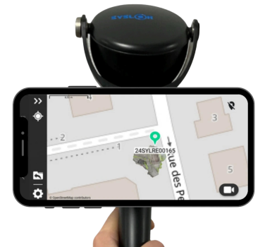
Turn your smartphone into a field digitizing tool: generate georeferenced 3D point clouds, usable orthophotos, and perform vectorization with EasyMap.

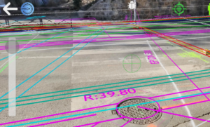
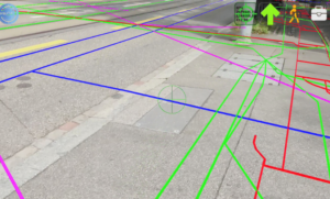
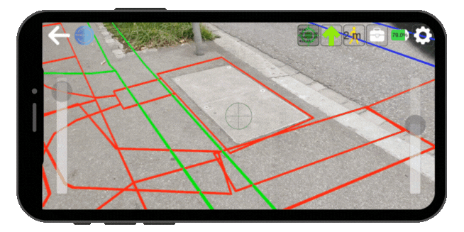
Thanks to our augmented reality technology, instantly visualize the exact location of underground networks, overlaid on your camera view.

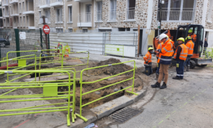
EasyField is a simple and precise digital field notebook for staking out, surveying, and monitoring earthworks — all directly from your smartphone.
They trust us
Our solutions are deployed across local authorities, engineering firms, network operators, contractors, and industrial or sensitive sites. These references reflect the trust of diverse stakeholders who rely on Syslor to secure their operations and ensure the reliability of their data.


Our Commitments
At Syslor, we don’t just provide technical solutions — we are committed to supporting industrial and sensitive sites with responsible, accessible, and durable tools. Every technological choice we make is driven by a clear purpose: delivering the reliability essential to critical environments while respecting your operational, regulatory, and safety constraints.

Digital sovereignty
Our equipment is designed and manufactured in France, and all data is hosted within national territory — technological sovereignty serving your operational security.

Efficiency & performance
Reducing damage, avoiding unnecessary travel, and improving network management — concrete actions to minimize environmental impact and promote sustainable management of territories.

Designed for your operational realities
Our mission: to make network data accessible, actionable, and useful in everyday operations — empowering you to make informed decisions and take effective action, both in the field and at the office.