Your complete solution from site layout to as-built drawings including utilities location plans and GNSS receiver.
Since 2017, SYSLOR has been innovating, filing patents and developing unique technological tools designed by and for field professionals. The solutions are designed to meet the needs of site teams, surveyors and utilities managers with efficiency and simplicity.
SYSLOR’s offer enables:
- Fast, accurate digitization of existing utilities plans.
- Site layout with GNSS and point marking directly in the field.
- Surveying points and automatic vectorisation of data
- Augmented reality visualization of pipes to avoid misinterpretation.
- Precise monitoring of earthworks.
- Accurate as-built capture and drawings, ready-to-use.
All this, with centimeter-level accuracy tailored to the requirements of public works and underground utilities.


The complete worksite case with GNSS receiver and accessories
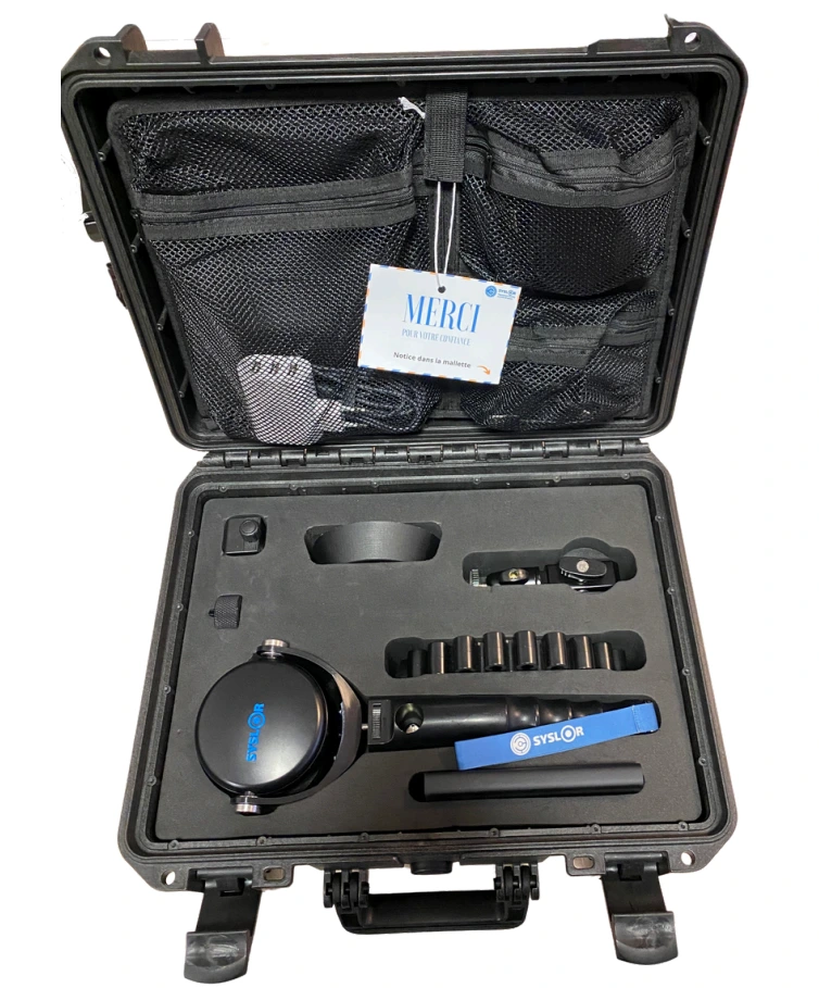
- GNSS receiver with RTK
- Induction charger with USB C cables
- External induction battery
- GNSS rod to GNSS receiver converter
- Centring base
- Smartphone, phablet or tablet holder to be specified when ordering.
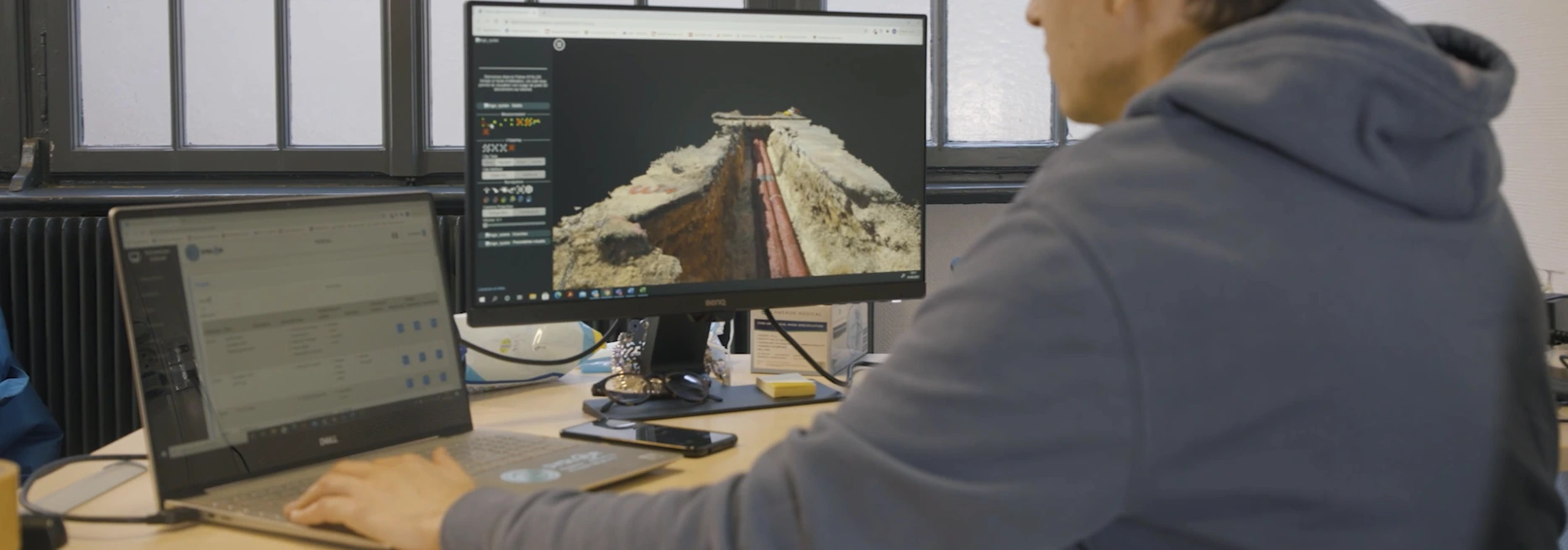
Your collaborative platform for optimised work management
Key features:
- Upload digitized plans
Import your utilities plans directly onto your own dedicated space via the SYSLOR web portal, ready to be used by your teams. - Share data with your team on site
Ensure smooth collaboration by sharing your digitized utilities plans in real time with your teams on site. - Interact in real time
The office can interact directly with on-site teams via EasyDesk, adjusting data and ensuring the accuracy of work. - Edit the survey plan (EasyScan option)
As a complement to EasyScan, SysMap makes it easy to edit and generate the survey plan on Syslor portal, without the need for any additional tools. - Immediate access to the site utilities plan
All plans and information are accessible immediately after processing, ensuring optimum fluidity for your operations.
The benefits of EasyDesk:
- Efficient collaboration: A space shared between office and field teams to simplify exchanges and ensure accuracy of work.
- Easy to use: An intuitive interface for both novice and experienced users.
- Time-saving: Centralise and share data on utilities and survey plan in real time to speed up the process.
Who is EasyDesk designed for?
- Project managers:Monitor and supervise work efficiently.
- Surveyors: No need to travel. Transmit utilities plan to the site teams, give instructions in real time and retrieve data to be processed directly from the office.
- Site teams: Access the information you need to carry out the work in real time.
Your simple, intuitive field notebook for site layout
Key features:
- Import utilities plans
- Upload your digital plans (DXF, CSV) from Syslor portal and access them in real time on site via the mobile application.
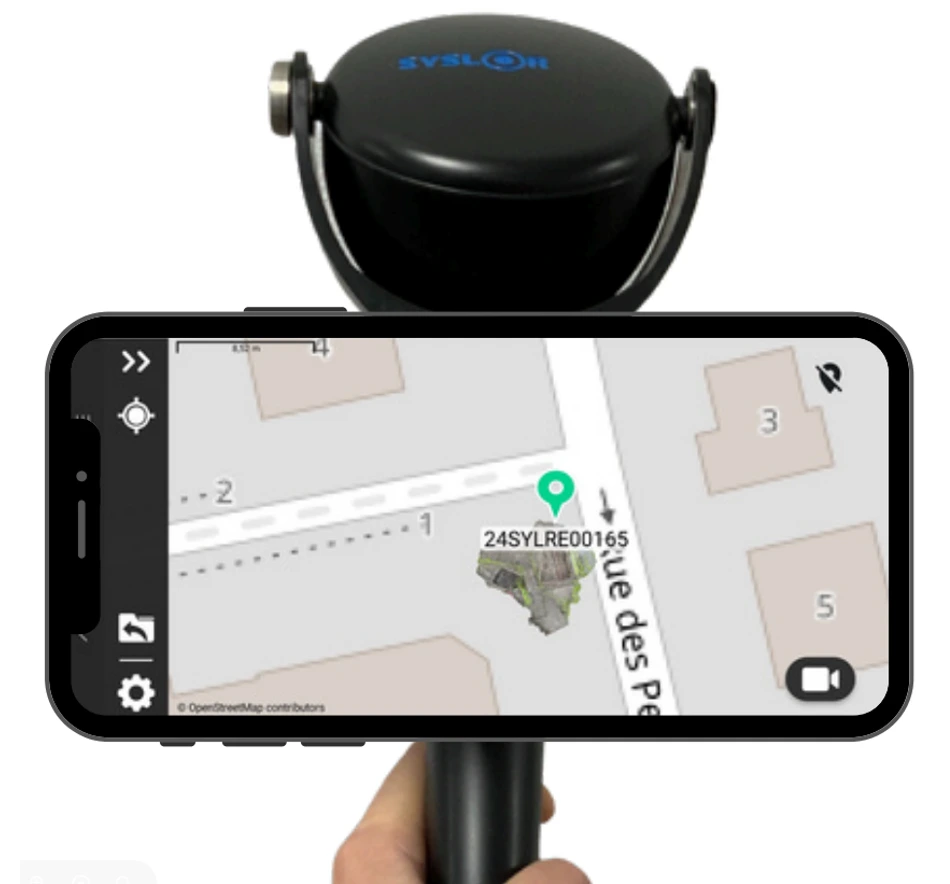
- Precise site layout: mark out points, lines or surfaces directly on site with centimetre accuracy, thanks to the connection to the GNSS receiver.
- Make the most of topographic surveys: Capture precise field data to enhance your projects. Export them easily in DXF or CSV format for processing or sharing.
- Benefits from intuitive guidance:View the elements to be installed on your mobile device and follow the guidance instructions in real time for error-free execution.
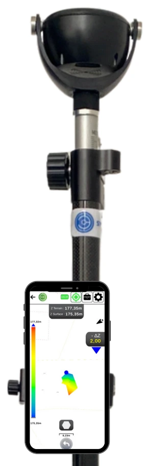
- Operate earthworks from a DTM: Lay out and control your earthworks directly from the projected surfaces of a digital terrain model.
The benefits of EasyField:
- Centimetre accuracy: Work with an accuracy tailored to the requirements of buried utilities and public works.
- Intuitive interface: Designed for users of all levels, EasyField requires no expertise in topography.
- Time-saving: Reduce site layout and survey times with tools optimised for the people on site.
- Interoperability: export and use your data in standard formats compatible with your usual software.
Who is EasyField designed for?
EasyField is designed for onsite and office professionals who need precise, easy-to-use tools:
- Site managers: to supervise site layout and ensure that work complies with the digital utilities plan.
- Surveyors: To manage site layout and surveys remotely, avoiding unnecessary travel. Transmit the necessary data to the field teams, retrieve the surveyed data and process it directly from the office.
- On site operators: Access the utilities map and instructions directly on their smartphone, with a simplified interface that guides them through each stage.
Dive into augmented reality to visualise your utilities and simplify marking and staking
Key features:
- Loading and conversion of utilities plans: Your mobile application converts the digitized utiities plans on the SYSLOR portal and makes them available to the field in augmented reality.
- Site layout accuracy: Connection to the GNSS receiver included in your case, or any other NMEA-standard GNSS receiver.
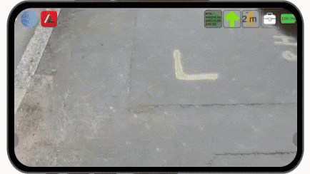
- Visualisation in the blink of an eye: pinpoint your buried pipes in real time.
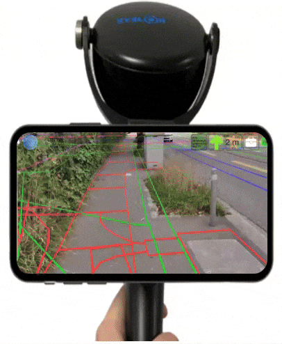
- Move around intuitively: Thanks to the digital twin of the open trench, you can view the networks beneath your feet in 3D augmented reality superimposed on your phone’s camera, whether you’re carrying out work or simulating redevelopment/construction projects.
- Marking and staking: eveneasier to do immediately.
The benefits of EasyView:
- Immerse yourself in the worksite: visualizing underground pipes in Augmented Reality is immersive, intuitive and fun.
- Speed up your preparation and improve safety: on site team can find their way around the site more quickly, for example during team/safety checkpoints, and avoid accidents.
- Centimetre accuracy: Work with an accuracy tailored to the requirements of underground utilities and public works.
- Intuitive interface: Designed for users of all levels, EasyView requires no expertise in topography.
- Time-saving: Cut work time in half by reducing site layout, marking and staking and surveying times thanks to tools optimised for the field.
- Interoperability: export and use your data in standard formats compatible with your usual software.
- Reduce errors: anticipatepotential errors in your projects before validating the plans with the client.
Who is EasyView designed for?
EasyView is designed for on site and office professionals who need precise, easy-to-use tools:
- Site managers: To supervise site layout / marking and staking and ensure that work conforms to the digital utilities plan.
- Surveyors: To manage remote installation and surveying, avoiding unnecessary travel. Transmit the necessary data to the field teams, retrieve the surveyed data and process it directly from the office.
- Field operators: Access the utilities map and instructions directly on their smartphone, with a simplified interface that guides them through every step.
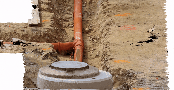
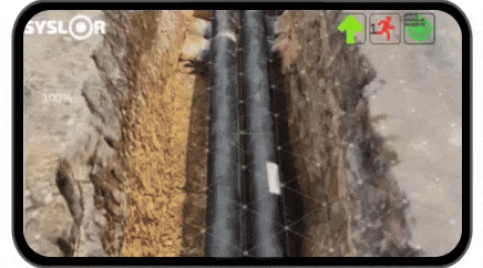
Capture your as-built trench to produce the as-built drawings without having to descend into it.
Key features:
- As-built scanning: The EasyScan mobile application enables you to film your open trench and generate a point cloud integrated in 3D on the as built plan before closing, using photogrammetry.
- Editing the as-built plan: With Sysmap, you can use various tools available on the collaborative portal to produce the certified as-built drawing.
- Collaboration: Archive and share the actual as-built view of the pipes after the works.
- Compliance: Supply of up-to-date as-built drawing data with Class A accuracy, which is then easily validated by your surveyor.
The benefits of EasyScan:
- Immediate capture of the trench:With just one video capture, you can preserve the actual geolocation of the pipes with maximum precision.
- As built 3D plan and polylines available: SYSMAP editor makes it easy to draw and retrieve polylines location of utilities.
- Easy deliverables: You can easily include the as built 3D plan in your deliverables.
Who is EasyScan designed for?
EasyScan is designed for on site and office professional who need accurate, easy-to-use tools:
- Site supervisors: to capture trench video in one shot before closing.
- Surveyors: to edit the as-built drawings and make it available.
Leverage your data with EasyMap
After your field capture, your photogrammetric data becomes accessible on EasyMap to:
Visualize your georeferenced point cloud directly over the network layout;
Trace and vectorize underground utilities with class A accuracy;
Generate longitudinal and cross-sectional profiles to ensure accurate network tracking;
Measure surface areas and calculate volumes (cut/fill) to better anticipate your resource needs;
Export your plans to your preferred tools (GIS, CAD, etc.).
You turn your field data into usable, certifiable, and ready-to-deliver outputs.
EasyField, EasyView and EasyScan mobile applications are available on:


Request a demo or more information
Click here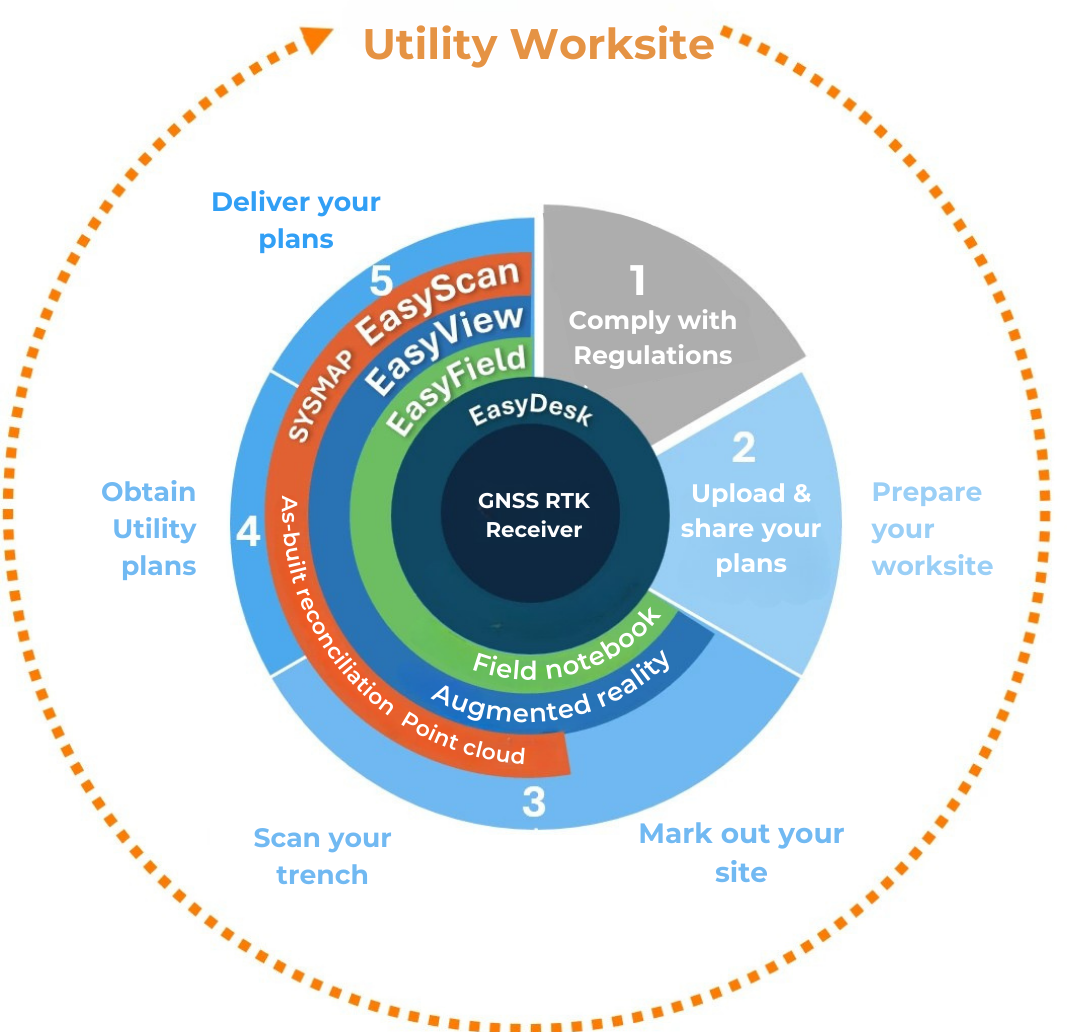
Innovative, collaborative tools
SYSLOR offers a truly modern and robust toolbox, combining the GNSS receiver with intuitive mobile applications and a collaborative web platform.
- For on site teams: Mobile applications coupled with the Proteus GNSS kit enable users, even those with no surveying experience, to access utilities maps easily and carry out complex tasks with total simplicity.
- For the office: The EasyDesk platform centralises field data, facilitates its vectorisations and updating of plans, and ensures smooth collaboration between the office and the field.
The solutions enable you to monitor the entire lifecycle of a site, connecting field and office teams in real time.
An optimised process for your worksites
- Preparation: After digitisation, the utilities plan is integrated into a collaborative web portal and shared with your onsite team.
- Marking and positioning: The team uses GNSS tools and mobile applications to mark and position utilities accurately.
- Earthworks monitoring: Operations are carried out with optimum precision, minimising the risk of damage to pipes.
- As-built drawing: A video of the trench is captured before it is closed, enabling an accurate and compliant completion plan to be drawn up.
The advantages of Syslor:
Why choosing us?
- Robust and reliable: Perfectly suited to demanding site environments.
- Easy to use: Intuitive interfaces make them quick to learn, even for novice users.
- Fast: Carry out your operations, from survey to completion, in record time.
- Centimetre accuracy: Solutions tailored to the requirements of utilities and infrastructures.
- Interoperable: Work with standardised formats for easy integration into your existing software (GIS).
A solution designed for you
Whether you are a site manager, surveyor, design office or utilities manager, Syslor is your partner. With Syslor, you can increase the accuracy, efficiency and peace of mind of your utilities site management.